
Mount Athos, Halkidhiki
Far away from the rest of Macedonia and the whole world as well, there is a natural and spiritual paradise with a special glory and magnificence, namely the eastern peninsula of Halkidiki, Mount Athos (Agion Oros), the bay of ancient Greeks or as monks put it, the “land of Virgin Maryâ€. It is a religious community with historical monasteries, cells in caves or between the rocks, towers, domes, belfries, chants, etc. Mount Athos is a big temple under the sky; it is the main carrier of Orthodox Christianity. Today Athos includes 20 monasteries, 12 skites, and about 700 houses, cells or hermitages. It is listed in UNESCO's WORLD HERITAGE MONUMENTS.Only men are allowed to visit Agion Oros, according to the Protocol of the monastic state. A few days before their visit, visitors have to phone Agion Oros offices in order to make their booking and receive a code number. This code number is necessary because the number of visitors is limited to 100 men per day. Women can view the monasteries from a cruise along the west coast of Mount Athos.

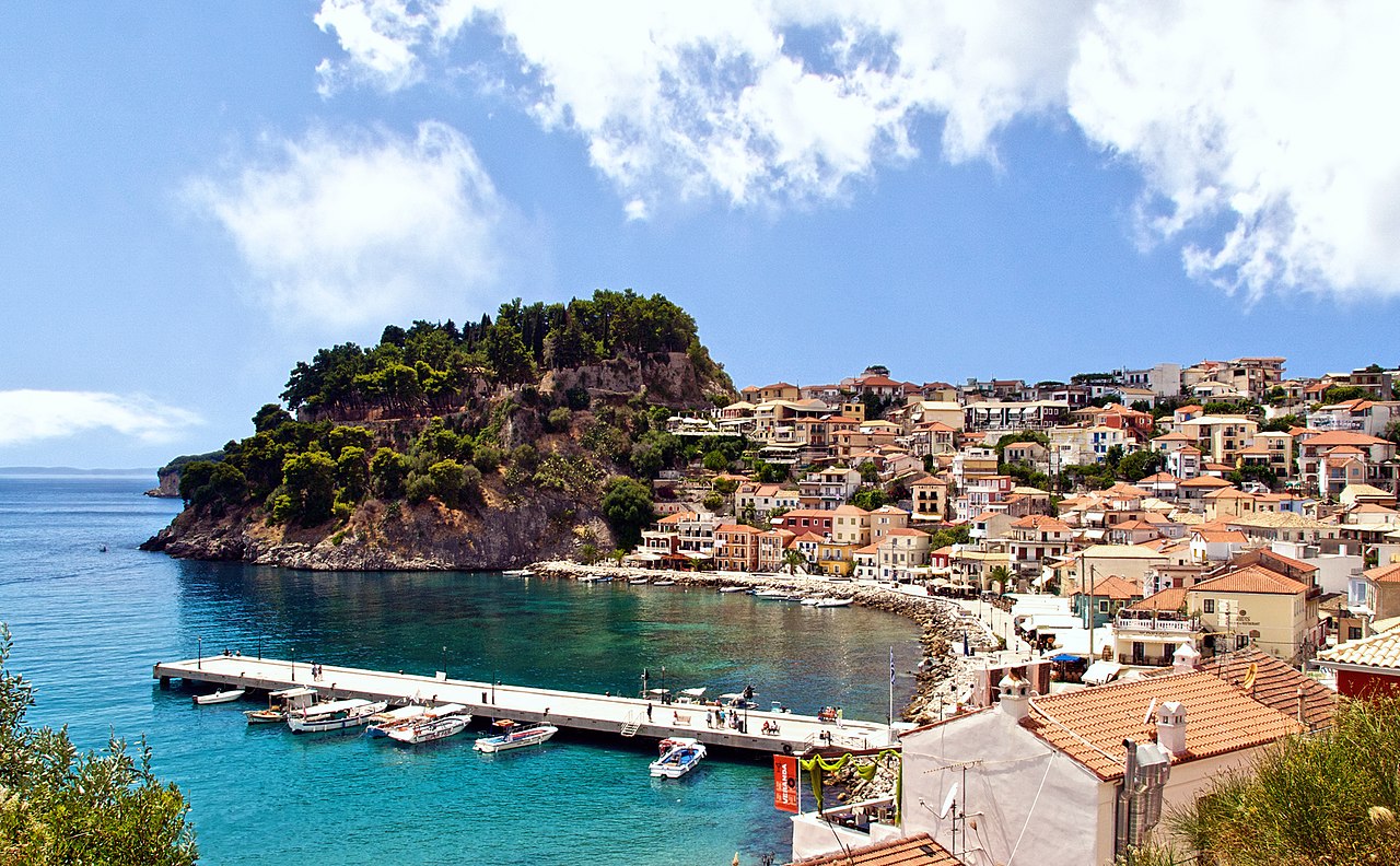
Parga, Epirus
Is a town and municipality located in the northwestern part of the regional unit of Preveza in Epirus, northwestern Greece. The seat of the municipality is the village Kanallaki.Parga lies on the Ionian coast between the cities of Preveza and Igoumenitsa. It is a resort town known for its scenic beauty.
The Castle is found on the top of a hill overlooking the town and was used to protect the town from the mainland and the sea. It was initially built in the 11th century by the residents of Parga to protect their town from pirates and the Turks. In the 13th century, as their control of the region increased, the Venetians rebuilt the castle to fortify the area. In 1452, Parga and the castle were occupied by the Ottomans for two years during which time part of the castle was demolished. 1537, Ottoman admiral Hayreddin Barbarossa burnt and destroyed the fortress and the houses within.
Before the reconstruction of the castle in 1572 by the Venetians, the Turks demolished it once again. The Venetians rebuilt it for the third and last time creating a perfect, strong fortress that stayed impregnable until 1819, despite attacks, especially by Ali Pasha of Ioannina, who besieged them from the castle of Agia-Anthousa. The Venetians created a perfect defence plan which they combined with the natural fortification made the fortress. Outside the castle eight towers placed in different positions completed the defence. Inside the narrow space of citadel there were 400 houses, positioned so that they occupied only a small space far away from the seaside. From this castle the free-besieged population of Parga and Souli fought epic battles, retaining their freedom for centuries. From the faucet “Kremasma” the tanks of the castle and the houses were provided with water. The castle for its provision used the two bays of Valtos and Pogonia. When Parga was sold to the Ottomans, Ali Pasha enhanced it even more by placing both its harem and Turkish bath at the top. This radically improved the rooms of the castle. On the arched gate at the castle entrance, on the wall, you can see the winged lion of Agios Markos, the name “ANTONIO BERVASS 1764”, emblems of Ali Pasha, two-headed eagles and relative inscriptions. Archways, gun emplacement rooms, supplies lodges, strong bastions with gun safe boxes, safe boxes of small arms, secret passage to the sea, barracks, jails, warehouses and two block-houses at the last defense line: prove the perfection of the defense plan, which along with the natural fortification, made the fortress unconquered.
Samaria Gorge, Crete
The gorge is in southwest Crete in the regional unit of Chania. It was created by a small river running between the White Mountains (Lefká Óri) and Mt. Volakias. There are a number of other gorges in the White Mountains. While some[who?] say that the gorge is 18 km long, this distance refers to the distance between the settlement of Omalos on the northern side of the plateau and the village of Agia Roumeli. In fact, the gorge is 16 km long, starting at an altitude of 1,250 m at the northern entrance, and ending at the shores of the Libyan Sea in Agia Roumeli. The walk through Samaria National Park is 13 km long, but one has to walk another three kilometers to Agia Roumeli from the park exit, making the hike 16 km long. The most famous part of the gorge is the stretch known as the Gates (or, albeit incorrectly, as "Iron Gates"), where the sides of the gorge close in to a width of only four meters and soar up to a height of almost 300 meters (980 feet). The gorge became a national park in 1962, particularly as a refuge for the rare kri-kri (Cretan goat), which is largely restricted to the park and an island just off the shore of Agia Marina. There are several other endemic species in the gorge and surrounding area, as well as many other species of flowers and birds.
The village of Samariá lies just inside the gorge. It was finally abandoned by the last remaining inhabitants in 1962 to make way for the park. The village and the gorge take their names from the village's ancient church, Óssia María.
A must for visitors to Crete is to complete the walk down the gorge from the Omalos plateau to Agia Roumeli on the Libyan Sea, at which point tourists sail to the nearby village of Sougia or Hora Sfakion, where they could spend a night there, or they could catch a coach back to Chania. The walk takes five to seven hours and can be strenuous, especially at the peak of summer.
Local tourist operators provide organized tours to the Gorge. These include bus transportation from one's hotel to the entrance (near Omalos village), and a bus connection that will be waiting for hikers after they disembark the ferry in Sougia or Sfakia (Chora Sfakion). If you are on your own, you can make a one-day round trip from Chania (see below) or from Sougia or Paleochora. Note that the morning buses from Sougia and Paleochora do not operate on Sunday. The ferries leave Agia Roumeli to Chora Sfakion (eastbound) and to Sougia/Paleochora (westbound) at 17:00.

Lindos, Rhodes
Nestling at the foot of a steep rock and beautifully surrounded by the sea lies the traditional settlement of Líndos; on the top of the same rock stands a centuries-old acropolis, proudly overlooking the archipelagos. The acropolis bears silent witness to Líndos’ glorious past, a major naval power of ancient times which reputedly had a population of 17,000. The landscape of Líndos encapsulates the essence of Rhodes: a surprisingly felicitous blend of ancient and medieval! With 600,000 visitors annually, Líndos competes with Delphi as the second most visited archeological site in Greece. Enjoy it!

Delphi Theatre
The theater at Delphi is build further up the hill from the Temple of Apollo and it presented the seated audience with a spectacular view of the entire sanctuary below and the valley beyond. It was built in the 4th c. B.C. our of local Parnassus limestone and was remodeled several times subsequently.
Its 35 rows can accommodate around five thousand spectators who in ancient times enjoyed plays, poetry readings, and musical events during the various festivals that took place periodically at Delphi. The lower tiers of seats were built during the Hellenistic and Roman periods.
.JPG)
Its 35 rows can accommodate around five thousand spectators who in ancient times enjoyed plays, poetry readings, and musical events during the various festivals that took place periodically at Delphi. The lower tiers of seats were built during the Hellenistic and Roman periods.
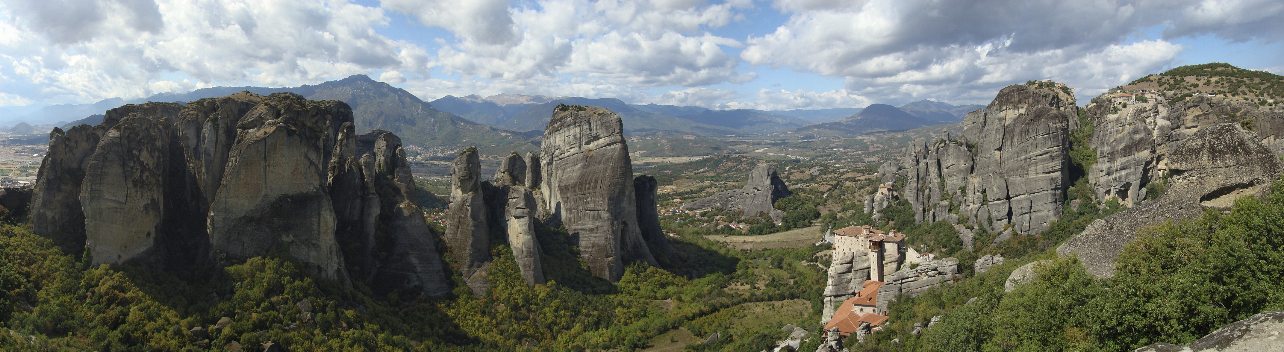
Meteora, Kalambaka
The Metéora (Greek: Μετέωρα, pronounced [mɛˈtɛoɾɐ], literally "middle of the sky", "suspended in the air" or "in the heavens above" — etymologically related to meteorology) - is a formation of immense monolithic pillars and hills like huge rounded boulders dominate the local area.
It is also associated with one of the largest and most precipitously built complexes of Eastern Orthodox monasteries in Greece, second in importance only to Mount Athos. The six monasteries are built on natural sandstone rock pillars, at the northwestern edge of the Plain of Thessaly near the Pineios river and Pindus Mountains, in central Greece.
Metéora is included on the UNESCO World Heritage List under criteria I, II, IV, V and VII.
The nearest town is Kalambaka.
Naxos,Cyclades
Naxos (Greek: Νάξος, pronounced [ˈnaksos]) is a Greek island—at 429 km2 (166 sq mi)[citation needed] the largest of the Cyclades island group in the Aegean. It was the centre of archaic Cycladic culture. The island is famous as a source of emery, a rock rich in corundum, which until modern time was one of the best abrasives available.
The largest town and capital of the island is Chora or Naxos City, with 6,533 inhabitants (2001 census). The main villages are Filoti, Apiranthos, Vivlos, Agios Arsenios, Koronos and Glinado.

The largest town and capital of the island is Chora or Naxos City, with 6,533 inhabitants (2001 census). The main villages are Filoti, Apiranthos, Vivlos, Agios Arsenios, Koronos and Glinado.
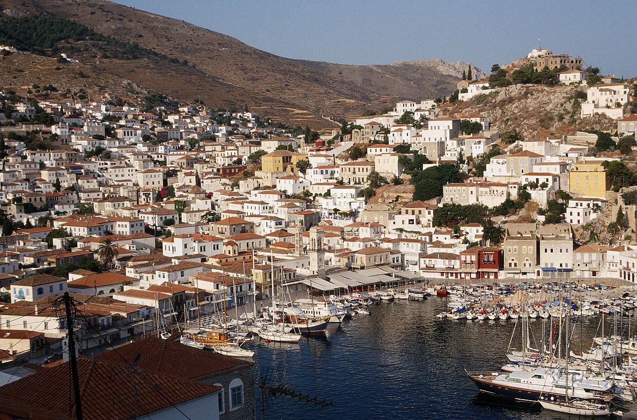
Island of ÝDHRA (Hydra)
The island of ÝDHRA (Hydra) is one of the most atmospheric destinations in Greece. Its harbour and main town preserved as a national monument, it feels like a Greek island should, entirely traffic-free (even bicycles are banned) with a bustling harbour and narrow stone streets climbing steeply above it. Away from the main settlement the rest of the island is roadless, rugged and barely inhabited. The charm hasn’t gone unnoticed – Ýdhra became fashionable as early as the 1950s, and in the Sixties characters ranging from Greek painter Nikos Hatzikyriakos-Ghikas to Canadian songster Leonard Cohen bought and restored grand old houses here. There’s still a sizeable expat community, which contributes to a relatively sophisticated atmosphere, and also noticeably high prices. But even the seasonal and weekend crowds, and a very limited number of beaches, can’t seriously detract from the appeal. When the town is overrun, it’s easy enough to leave it all behind on foot or by excursion boat. The interior is mountainous and little-visited, so with a little walking you can find a dramatically different kind of island – one of rural cottages, terraces of grain to feed the donkeys, hilltop monasteries and pine forest.
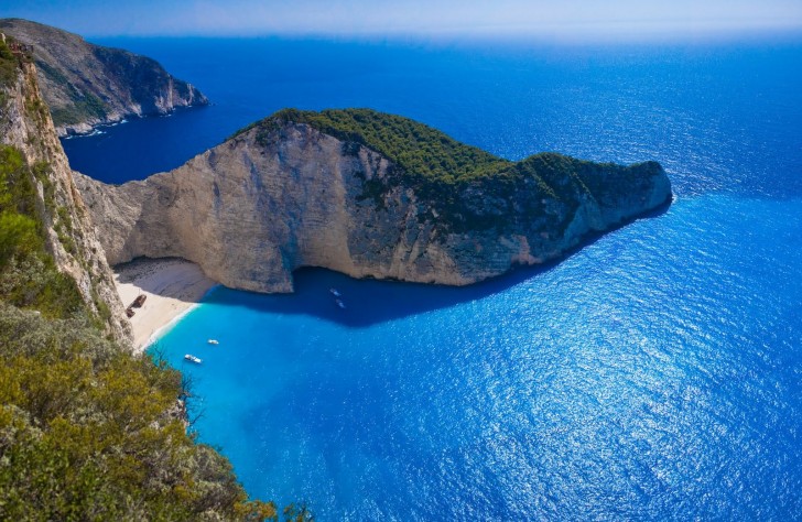
Navagio beach, Zakynthos
Navagio Beach (Greek: Ναυάγιο, pronounced [naˈvaʝo]), or Shipwreck Beach, is an exposed cove, sometimes referred to as "Smugglers Cove", on the coast of Zakynthos, in the Ionian Islands of Greece. Navagio Beach was originally known as Agios Georgios. On October 2, 1980, a freightliner, the MV Panagiotis, ran aground in the waters around Zakynthos Island right on Navagio Beach after stormy weather and bad visibility. Many people falsely claim the ship was smuggling contraband cigarettes, wine and women. Although and recently, MV "PANAGIOTIS" Captain Charalambos Kompothekras - Kotsoros released the real story about what happened. The ship was abandoned and still rests buried in white sandy dunes of the beach that now holds the famous nickname Navagio Beach (Shipwreck beach).
Navagio is located on the north-west shore of Zakynthos (Zante), in the Municipality of Elation. The area is defined by its sheer limestone cliffs, white sand beaches, and clear blue water, which attract thousands of tourists yearly. The strip of beach is accessed only by boat. Regular tours to the beach depart from Porto Vromi to the south, and from Agios Nikolaos and Cape Skinari to the north-east. Boats also arrive from the harbour of Zakynthos city.
Navagio is located on the north-west shore of Zakynthos (Zante), in the Municipality of Elation. The area is defined by its sheer limestone cliffs, white sand beaches, and clear blue water, which attract thousands of tourists yearly. The strip of beach is accessed only by boat. Regular tours to the beach depart from Porto Vromi to the south, and from Agios Nikolaos and Cape Skinari to the north-east. Boats also arrive from the harbour of Zakynthos city.
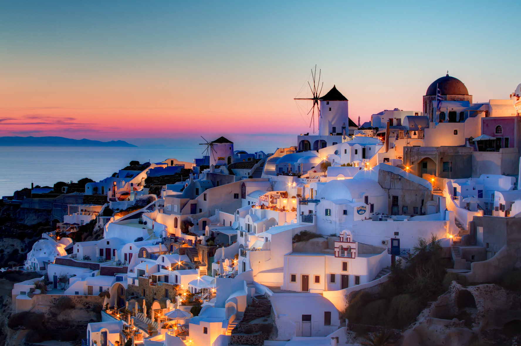
Santorini, Cyclades
Crescent-shaped Santorini (or Thíra), the precious gem of the Aegean, is actually a group of islands consisting of Thíra, Thirassiá, Asproníssi, Palea and Nea Kaméni in the southernmost part of Cyclades.
Did you know that the whole complex of Santorini islands is still an active volcano (the same as Méthana, Mílos and Nísiros) and probably the only volcano in the world whose crater is in the sea? The islands that form Santorini came into existence as a result of intensive volcanic activity; twelve huge eruptions occurred, one every 20,000 years approximately, and each violent eruption caused the collapse of the volcano’s central part creating a large crater (caldera). The volcano, however, managed to recreate itself over and over again.
A visit to Santorini is the ultimate gastronomic experience, as the island is a true culinary paradise! Treat your taste buds to some famous traditional products like cherry tomatoes, white egg plants, fava, caper and “hloró tyrí”, a special kind of fresh goat cheese found on the island, or why not try some of the exceptional wines produced from grapes grown in the volcanic soil of the island! Assyrtiko, Athyri, Aidani, Mantilaria and Mavrotragano are just some of the distinctive varieties that you can taste at the island’s famous wineries (some of them operate as a museum as well) or at restaurants.
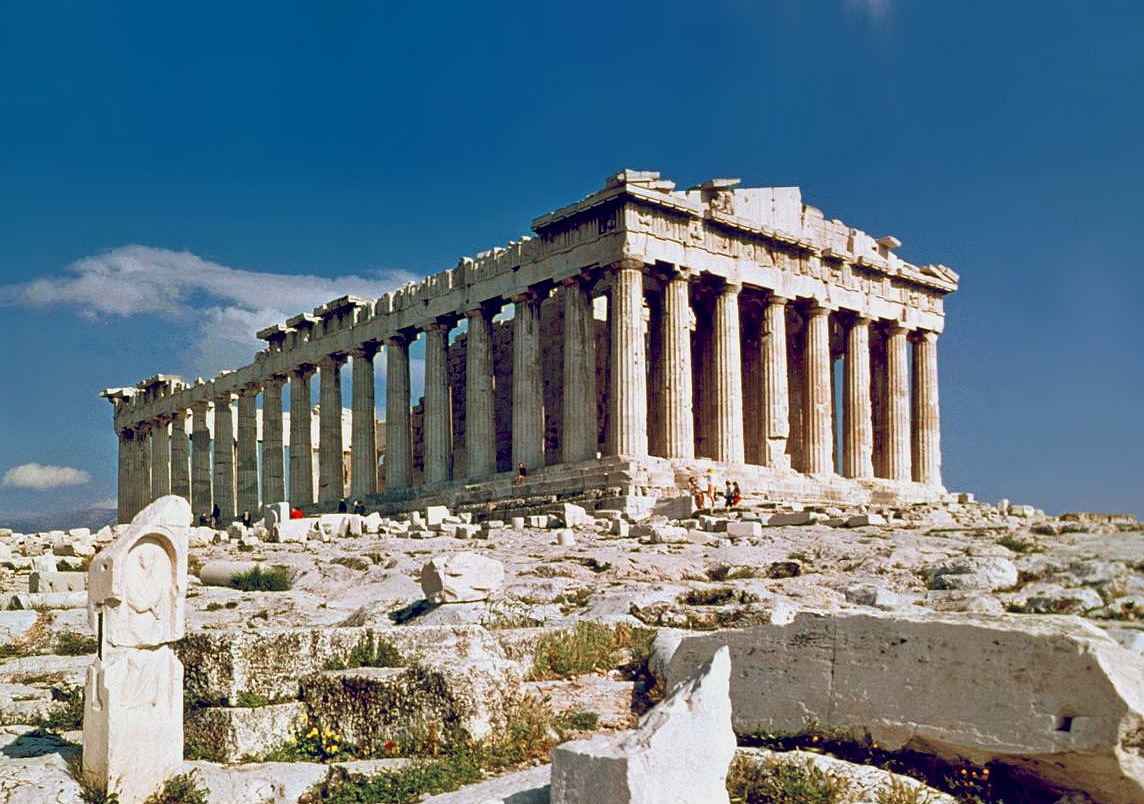
Parthenon, Acropolis, Athens
One of the most visited and most popular places in whole Greece
The Parthenon ( Ancient Greek: Παρθενών; Modern Greek: Παρθενώνας, Parthenónas) is a former temple, on the Athenian Acropolis, Greece, dedicated to the goddess Athena, whom the people of Athens considered their patron. Construction began in 447 BC when the Athenian Empire was at the peak of its power. It was completed in 438 BC although decoration of the building continued until 432 BC. It is the most important surviving building of Classical Greece, generally considered the zenith of the Doric order. Its decorative sculptures are considered some of the high points of Greek art. The Parthenon is regarded as an enduring symbol of Ancient Greece, Athenian democracy and western civilization, and one of the world's greatest cultural monuments. The Greek Ministry of Culture is currently carrying out a program of selective restoration and reconstruction to ensure the stability of the partially ruined structure.
The Parthenon ( Ancient Greek: Παρθενών; Modern Greek: Παρθενώνας, Parthenónas) is a former temple, on the Athenian Acropolis, Greece, dedicated to the goddess Athena, whom the people of Athens considered their patron. Construction began in 447 BC when the Athenian Empire was at the peak of its power. It was completed in 438 BC although decoration of the building continued until 432 BC. It is the most important surviving building of Classical Greece, generally considered the zenith of the Doric order. Its decorative sculptures are considered some of the high points of Greek art. The Parthenon is regarded as an enduring symbol of Ancient Greece, Athenian democracy and western civilization, and one of the world's greatest cultural monuments. The Greek Ministry of Culture is currently carrying out a program of selective restoration and reconstruction to ensure the stability of the partially ruined structure.

No comments:
Post a Comment